So, every state has a unique shape. Even Wyoming and Colorado are different-sized rectangles. By the way, what’s with those two? It’s like map makers just got bored at the end of the day and drew four lines with their T-squares. Even Kansas, as one-dimensional as a sheet of paper, has a little oops in the upper right-hand corner where Missouri slouches into it.
But I digress.
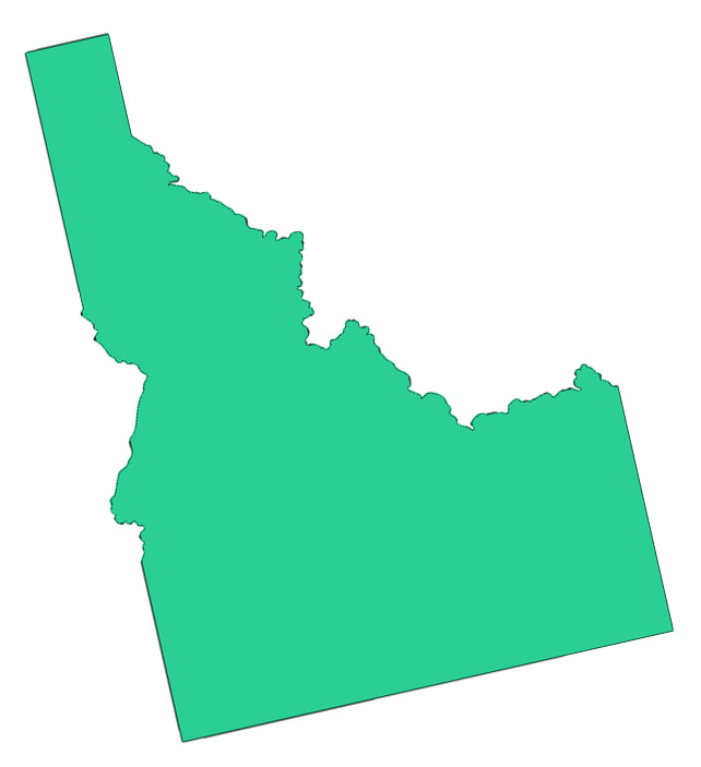
The shape of Idaho just wants to be noticed. It has that gnome-sitting-in-a-chair thing going for it. Its face stares into Montana while Montana, rudely, stares into Idaho’s belly. It’s one of a handful of states that extends more vertically than horizontally, as if it is always in ascension.
And it has a legend.
In 1863, when Idaho became a territory, its boundaries included most of Wyoming, and all of Montana. That didn't last long, though. Congress carved Montana out of Idaho Territory in May of 1864, choosing the Bitterroot Mountain Range as the main border between the two territories.
Somehow, though, a legend grew up that the boundary resulted from a surveying error. According to this tale, the border was supposed to follow the Continental Divide all the way to Canada. Idaho would have included Missoula, Butte, and all of Montana west of the Rockies--a nice little piece of land.
The story goes that the surveyors were drunk, or they had been paid off by agents from Montana who wanted a bigger territory. It's a splendid story, but it isn't true. In fact, the boundary between Montana and Idaho wasn't even officially surveyed until fourteen years after Idaho statehood. The states simply got along knowing that the border generally followed the crest of the Bitterroots, as designated by the U.S. Congress.
In the years leading up to statehood; there was a lot of haggling and political maneuvering over where Idaho's borders should be. But drunken surveying crews did not play a part in shaping the state.
One footnote. I’m told the boundary legend tale came about because surveyors had a habit of dropping their empty refreshment bottles in the hole when they placed survey markers.
But I digress.
The shape of Idaho just wants to be noticed. It has that gnome-sitting-in-a-chair thing going for it. Its face stares into Montana while Montana, rudely, stares into Idaho’s belly. It’s one of a handful of states that extends more vertically than horizontally, as if it is always in ascension.
And it has a legend.
In 1863, when Idaho became a territory, its boundaries included most of Wyoming, and all of Montana. That didn't last long, though. Congress carved Montana out of Idaho Territory in May of 1864, choosing the Bitterroot Mountain Range as the main border between the two territories.
Somehow, though, a legend grew up that the boundary resulted from a surveying error. According to this tale, the border was supposed to follow the Continental Divide all the way to Canada. Idaho would have included Missoula, Butte, and all of Montana west of the Rockies--a nice little piece of land.
The story goes that the surveyors were drunk, or they had been paid off by agents from Montana who wanted a bigger territory. It's a splendid story, but it isn't true. In fact, the boundary between Montana and Idaho wasn't even officially surveyed until fourteen years after Idaho statehood. The states simply got along knowing that the border generally followed the crest of the Bitterroots, as designated by the U.S. Congress.
In the years leading up to statehood; there was a lot of haggling and political maneuvering over where Idaho's borders should be. But drunken surveying crews did not play a part in shaping the state.
One footnote. I’m told the boundary legend tale came about because surveyors had a habit of dropping their empty refreshment bottles in the hole when they placed survey markers.


 RSS Feed