The Just-Reid family is celebrating the Sesquicentennial Plus One of Nels and Emma Just settling in the Blackfoot River Valley near Blackfoot. We had planned to celebrate last year, but that got put on hold along with so much else when COVID hit.
In honor of Sesquicentennial Plus One, I’m devoting the Speaking of Idaho blog to my family’s history during August.
In honor of Sesquicentennial Plus One, I’m devoting the Speaking of Idaho blog to my family’s history during August.
My great grandfather Nels Just, who had recently become a naturalized citizen, was proud of his adopted country. When his brick house along the Blackfoot River was finished in 1887, he ordered a four foot by six foot General Land Office Map of the United States, mounting it to the wall in the hallway of the new house.
The house doubled as the Post Office for Presto, Idaho Territory, then Presto, Idaho beginning in 1890. My great grandmother Emma Just was the postmistress for 13 years, welcoming postal patrons into her home, handing them their mail, and often talking with them about current events, using the map as a conversation tool.
The large map, varnished to ward off fingerprints, had hung unprotected for 127 years. Small pieces of the map had flaked off and it had discolored over the years. In 2014 our family decided to restore and protect the map so it would last at least another century.
With help from the Idaho Heritage Trust, we contracted with a restoration specialist in New York City. To get it to New York, we had to take it off the wall and ship it. That was a process that took several hours. Textile Conservator Diana Hobart Dicus supervised the work.
The map had been mounted on the wall by Nels with lath strips using tacks. The process of safely taking it down included the use of a large “folder” built from fiber board to assure the map stayed flat and did not fall and crumple.
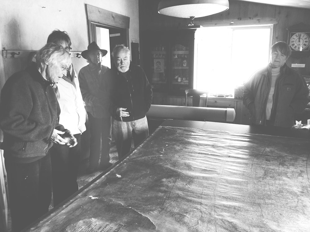
Once we got the map down flat on the large kitchen table in the house, we began removing the lath and tacks. It was then that we discovered that about a one-inch strip at the bottom of the map was missing. Nels had cut it off, none too cleanly. Why? We can’t know, but my guess is that he cut the lath to fit the map, then discovered he’d trimmed the side slats an inch too short. He wasn’t about to harness up a team to take into town to get more lath. So, his solution was just to haggle off the bottom of the map. No one would know. And no one did know until 127 years later. I confess, I would have done the same thing.
We rolled the map on an acid-free cardboard tube, wrapped the map with acid-free paper, placed it in an acid-free box, then placed the box in a length of plastic sewer pipe, filling it out with packing material. We used fitted sewer pipe ends to seal the map and shipped it to New York City.
Restoration on a wall map of this nature first involves removing the map from the original linen backing and then removing the glossy varnish coating the recto. The caustic glues common in the 19th century and the slowly degrading varnish, and exposure to temperature variation, had caused the moderate yellowing and chipping to the map. By having both the linen backing and the varnish removed, the restorer could then access the printed paper map to begin the repair work. When that was finished, the map was laid down on fresh linen and the edging was replaced.
A few months later, the map came back. We had Todd Hanson of Hanson’s Design and Fabrication in Meridian custom build a handsome case for the map, using museum grade Plexiglas to protect it. We displayed the restored map at the Idaho State Historical Archives for a few weeks, and at the Boise Public Library. The Idaho Statehouse hosted it for a day, then it headed to Blackfoot. It was displayed at the Blackfoot Library for a time, then returned to the hallway where it belongs.
The house doubled as the Post Office for Presto, Idaho Territory, then Presto, Idaho beginning in 1890. My great grandmother Emma Just was the postmistress for 13 years, welcoming postal patrons into her home, handing them their mail, and often talking with them about current events, using the map as a conversation tool.
The large map, varnished to ward off fingerprints, had hung unprotected for 127 years. Small pieces of the map had flaked off and it had discolored over the years. In 2014 our family decided to restore and protect the map so it would last at least another century.
With help from the Idaho Heritage Trust, we contracted with a restoration specialist in New York City. To get it to New York, we had to take it off the wall and ship it. That was a process that took several hours. Textile Conservator Diana Hobart Dicus supervised the work.
The map had been mounted on the wall by Nels with lath strips using tacks. The process of safely taking it down included the use of a large “folder” built from fiber board to assure the map stayed flat and did not fall and crumple.
Once we got the map down flat on the large kitchen table in the house, we began removing the lath and tacks. It was then that we discovered that about a one-inch strip at the bottom of the map was missing. Nels had cut it off, none too cleanly. Why? We can’t know, but my guess is that he cut the lath to fit the map, then discovered he’d trimmed the side slats an inch too short. He wasn’t about to harness up a team to take into town to get more lath. So, his solution was just to haggle off the bottom of the map. No one would know. And no one did know until 127 years later. I confess, I would have done the same thing.
We rolled the map on an acid-free cardboard tube, wrapped the map with acid-free paper, placed it in an acid-free box, then placed the box in a length of plastic sewer pipe, filling it out with packing material. We used fitted sewer pipe ends to seal the map and shipped it to New York City.
Restoration on a wall map of this nature first involves removing the map from the original linen backing and then removing the glossy varnish coating the recto. The caustic glues common in the 19th century and the slowly degrading varnish, and exposure to temperature variation, had caused the moderate yellowing and chipping to the map. By having both the linen backing and the varnish removed, the restorer could then access the printed paper map to begin the repair work. When that was finished, the map was laid down on fresh linen and the edging was replaced.
A few months later, the map came back. We had Todd Hanson of Hanson’s Design and Fabrication in Meridian custom build a handsome case for the map, using museum grade Plexiglas to protect it. We displayed the restored map at the Idaho State Historical Archives for a few weeks, and at the Boise Public Library. The Idaho Statehouse hosted it for a day, then it headed to Blackfoot. It was displayed at the Blackfoot Library for a time, then returned to the hallway where it belongs.
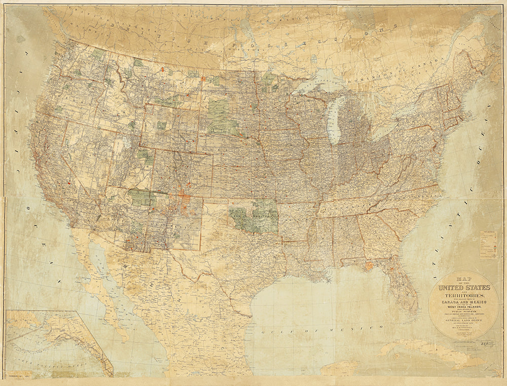
The 1887 map. This is a scan of the restored map before it was put in its case. Note that the map is much brighter than it was before restoration, but one can still see streaks of varnish. It would have damaged the map to do further removal of the coating. Because of the lighting conditions in the hallway where the map hangs in its new case it is very difficult to get photo of in situ.
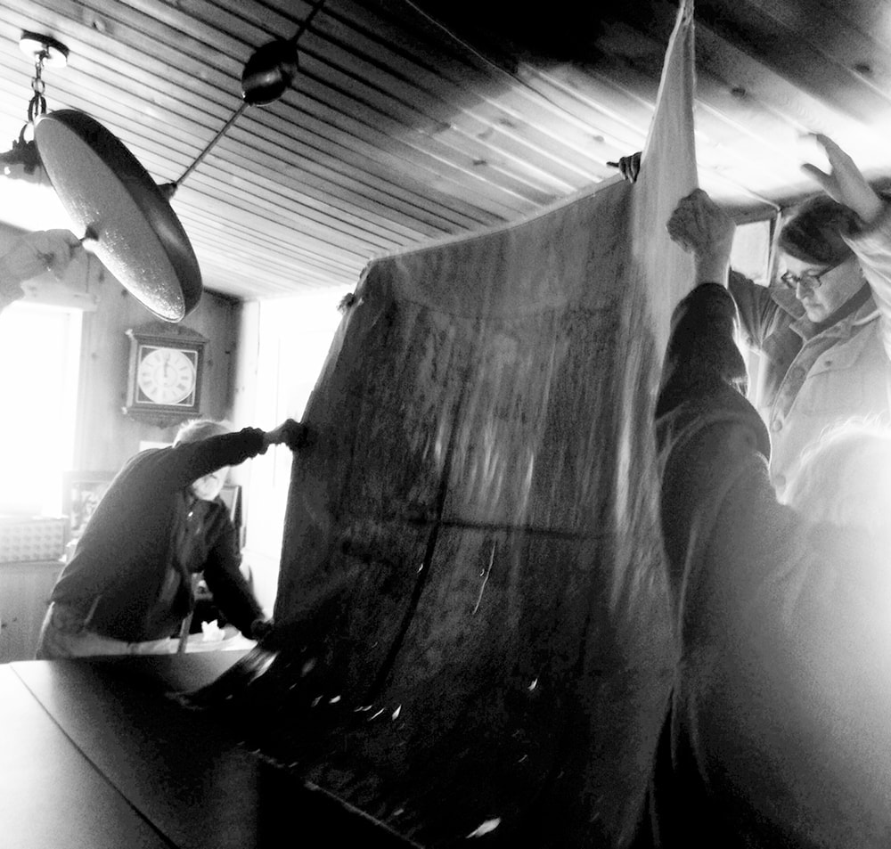
Electricity was long ago shut off in the 1887 house, so we were working with only what natural light came in through the kitchen windows. Some of the details show up better in black and white. For instance, as the map is being flipped over you can see by the backlighting that it is a series of six printed panels taped together on the back.
Textile Conservator Diana Hobart Dicus, left, gave us instruction on how best to remove the lath once the map was flat on the table. In the background you can see the large plastic tube that would serve as the hard shipping container for the map.
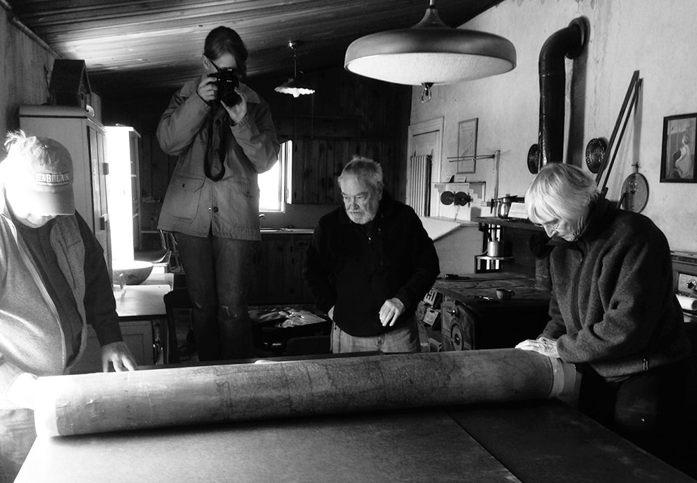
The map was carefully wrapped and rolled before being placed in an acid-free cardboard box, then inserted into the shipping container.


 RSS Feed