Most highways in Idaho have regular markers to alert you to speed limits, impending crashes if you fail to stop, and the mileage to the next three towns. That’s all very handy, but what if you’re commuting by air? Nowadays, with sophisticated navigational equipment, getting around in an airplane is something akin to that map app on your phone that speaks to you in a calm voice while you yell at it. In earlier days of airplanes, getting around was done more by the seat of the pants, a cliché that owes its existence to flying.
A pilot could easily get a bit off course and think that town below her was Rigby when it was really Rexburg. So, airmarking was invented. In 1934, Phoebe F. Omlie, Special Assistant for Air Intelligence of the National Advisory Committee for Aeronautics, convinced the Bureau of Air Commerce to start a program whereby each state would mark their towns and cities so they could be seen from the air. Note that there is an additional hierarchy of names and acronyms associated with the program from which I’ve just saved you. You’re welcome.
Note, too, that our fictional pilot trying to discern Rigby from Rexburg in the example above was female. That’s a little nod to the fact that the airmarking project was the first US government program “conceived, planned, and directed by a woman with an all-woman staff,” according to the website of the Ninety-Nines, the leading organization of woman pilots.
The idea was to paint the name of a town on the roof of a building in bright yellow paint, outlined in black. Idaho participated in the program, but before we get to that, I want to point out that it was successful. Too successful. When WWII came along, officials determined that it was not such a good idea to provide enemy bombers with a “you are here” locater. The program quickly switched from painting town names on warehouse roofs to painting over town names on warehouse roofs, at least in coastal states. After the war, the paint switched from black back to yellow.
Every town in Idaho with a roof big enough for letters got its 20-foot-high sign. Typically, the State Department of Aeronautics hired a college crew during the summer to paint the whole state every five years or so. In 1963, they began dividing the state into three regions and doing one region a year.
In addition to the town name, a symbol pointed to the nearest airport, and a numeral indicated how far away it was. Some symbols pointed to a couple of nearby airports.
The state no longer runs the program, but as recently as 2005, the Idaho Chapter of the Ninety-Nines was keeping some of the rooftop signs in good repair.
A related project, accomplished in conjunction with the Forest Service, marked every Forest Service lookout in Idaho with a number, again to provide pilots with navigational aids. In 1963, Kenneth Dougal, a college student from Boise, was contracted to paint every lookout in Idaho north of the Salmon River. That meant driving a panel truck to the top of a mountain, slapping on some big numbers, and winding his way down the mountain toward the next lookout. He managed to paint 110 lockouts and microwave tower buildings. To do so, he flew 160 miles by helicopter, rode a horse 92 miles, walked 75 miles, rode a tote-goat (an early, not very sophisticated off-highway motorbike) 45 miles, and drove the panel truck 8,000 miles. That little tidbit is courtesy of the October 1963 Rudder Flutter, the official publication of the Idaho Department of Aeronautics.
That department is now the Division of Aeronautics in the Idaho Department of Transportation. My thanks to Airport Planning and Development Manager Bill Statham and Administrative Assistant Tammy Schoen for providing me with a wealth of information on this subject.

A Forest Service lookout getting its airmarker number.
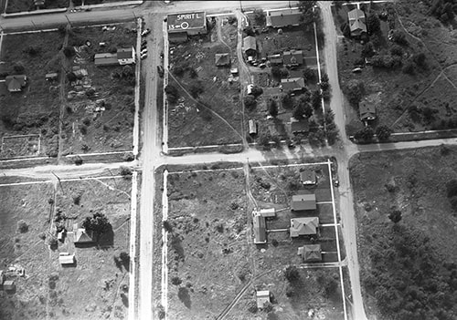
It's a little difficult to see, but that's Spirit Lake's air marker at the top of this aerial photo.

 RSS Feed